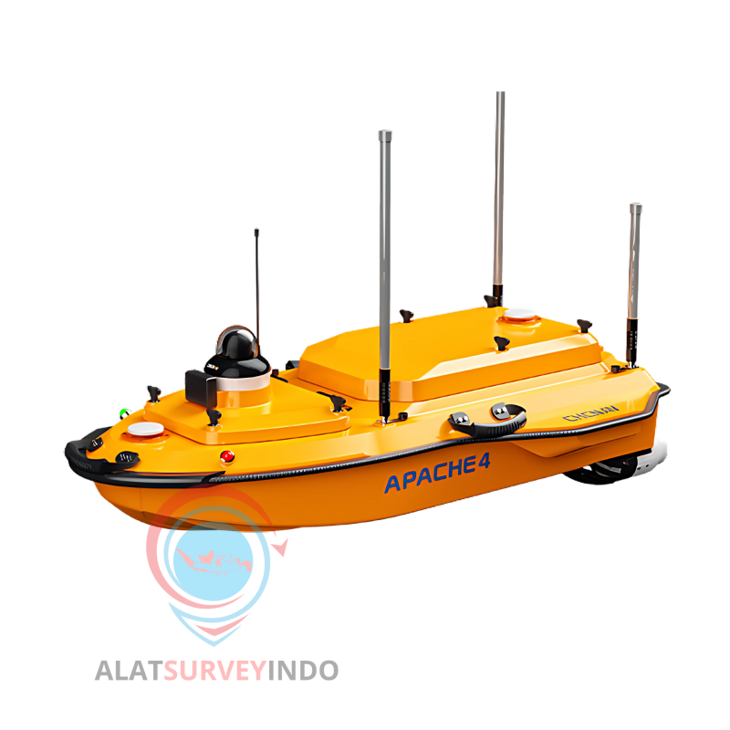


APACHE 4
· Advanced navigation controller
· Compatible with common ADCPS
· Built-in single beam echo sounder
· Smart positioning and navigation
· Maximum motor speed 7200 rpm
· Battery endurance 2 x 3 hour
· Network bridge: 1 km and 4G: unlimited
· R/C communication 2.4 GHz
· Nano SIM card slot
· Channel 432
· IMU update rate 200 Hz
· Maximum payload 35 kg
 Security policy
Pembelian dijamin aman
 Delivery policy
Gratis ongkir se-JOBODETABEK
 Return policy
Garansi Resmi dan Jaminan kemudahan retur
Physical |
|
| Hull dimension (L × W × H) | 1200 mm x 750 mm x 400 mm |
| Material | Macromolecule polyester carbon fiber |
| Weight (w/o instrument and battery) | 13 kg |
| Maximum payload | 35 kg |
| Anti-wave & Wind | 3rd wind level and 2nd wave level |
| Hull design | Triple-hull vessel |
| Water proof | IP67 |
| Draft | 12 cm |
| Indicator Light | Two-color light (Display satellite and positioning status) |
| Camera | 360° omnidirectional video |
| ADCP Mounting aperture | 240 mm |
| ADCP Compatibility | Compatible with M9, RiverPro, RiverRay, RioGrande, RCP and other navigable ADCP |
| Monted Device | ADCP and sounder are equipped at the same time. Expandable sampling, water quality meter, side scan |
| Safe | Shoal automatic astern, millimeter-wave radar automatic obstacle avoidance, low battery auto-return, signal loss auto-return |
| Obstacle avoidance distance | 0.2-40 m |
| Power | |
| Type | Electric |
| Propeller type | Brushless DC |
| Direction control | Veering without steering engine |
| Maximum motor power | 800 W |
| Maximum motor speed | 7200 rpm |
| Li-ion battery capacity | 4 x 23.1Ah 32.4 V 1 x 15 Ah 18 V |
| Battery endurance | 2 x 3 hours @ 2 m/s (running on 2 battery sets, support hotswap) |
| Maximum speed | 6 m/s |
| Communication | |
| Data communication | Network bridge: 1 km and 4G: unlimited |
| R/C communication | 2.4 GHz |
| Remote control range | 1 km |
| SIM Card slot | Nano SIM |
| Interface | |
| Interface | 2 x RJ45 port 3 x RS232 serial port 1 x PPS |
| Navigation mode | Manual or Auto-Pilot |
| Water proof of master control | IP67 |
| Data storage | Local multi-sessions and FTP push |
Positioning |
|
| Satellite system | BDS B1/B2, GPS L1/L2, GLONASS L1/ L2, Galileo E1/E5, QZSS |
| Channel | 432 |
| Single point position (RMS) | Horizontal: 1.5 m Vertical: 2.5 m |
| SBAS Positioning accuracy | Horizontal: 0.5 m Vertical: 0.85 m |
| DGNSS positioning accuracy | Horizontal: 0.4 m + 1 ppm Vertical: 0.85 m + 1 ppm |
| RTK Positioning accuracy | Horizontal: ±8 mm + 1 ppm Vertical: ±15 mm + 1 ppm |
| Heading accuracy | 0.2 ⁰ @1 m baseline |
| Inertial navigation accuracy | 6 ⁰/ h |
| IMU update rate | 200 Hz |
D270 Single Beam Echo Sounder |
|
| Data type | CHCGD NMEA SDDPT/SDDBT, original waveform |
| Weight | 0.84 kg |
| Sounding range | 0.15 m to 200 m |
| Sounding accuracy | ±0.01 m + 0.1% x D (D is the depth of water) |
| Resolution | 0.01 m |
| Frequency | 200 KHz |
| Beam angle | 6.5° ± 1° |
| Supply voltage | 10-36 V DC/ 100-20 V AC |
| Waterproof | IP67 |
Software |
|
| Hydro Survey | Data collection and post-processing. Support coordinate conversion, trajectory, water depth, waveform real-time display, post-processing support waveform overlay and attitude correction. |
| Auro Planner | Route planning, autonomous navigation, hull parameter control, multi-angle video display, and system self-test at power-on. |

APACHE 4
· Advanced navigation controller
· Compatible with common ADCPS
· Built-in single beam echo sounder
· Smart positioning and navigation
· Maximum motor speed 7200 rpm
· Battery endurance 2 x 3 hour
· Network bridge: 1 km and 4G: unlimited
· R/C communication 2.4 GHz
· Nano SIM card slot
· Channel 432
· IMU update rate 200 Hz
· Maximum payload 35 kg