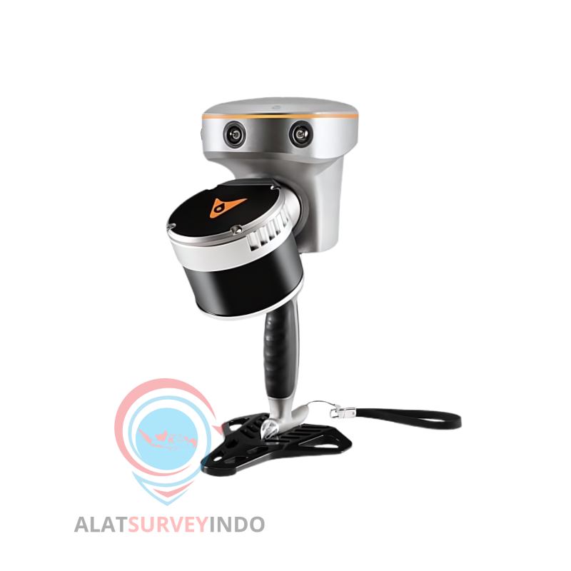


CHCNAV SLAM RS 10
Dirancang untuk meningkatkan efisiensi di berbagai aplikasi pemetaan dan survei, pemindai laser RS10 menyediakan alat serbaguna dan lengkap bagi para profesional untuk menangkap data geospasial 3D yang lengkap di lingkungan luar dan dalam ruangan. Dengan menggabungkan penerima GNSS RTK kelas survei dengan sistem LiDAR SLAM genggam, RS10 menyederhanakan alur kerja tanpa mengorbankan akurasi atau fleksibilitas.
 Security policy
Pembelian dijamin aman
 Delivery policy
Gratis ongkir se-JOBODETABEK
 Return policy
Garansi Resmi dan Jaminan kemudahan retur
RTK AND SLAM FUSION FOR BETTER ACCURACY MAPPING
The RS10 integrates a state-of-the-art GNSS Smart Antenna for RTK positioning accuracy even in challenging environments. Combined with the system's high-precision LIDAR and three HD cameras, it fuses RTK, laser, and visual SLAM to deliver 5cm absolute measurement accuracy. From detailed architectural surveys to complex infrastructure projects, the RS10 gives professionals the tools they need to collect detailed, accurate data efficiently.
REAL-TIME SLAM CAPABILITIES
With a powerful on-board processor, the RS10 laser Scanner enables real-time georeferenced point cloud generation in the field. Users receive instant feedback, allowing them to make adjustments while scanning to ensure complete and detailed coverage. Large sites up to 13,000 square meters can be mapped in real-time.
EFFICIENT LOOP-FREE OPERATION
The integration of high-precision GNSS and SLAM technologies eliminates the need for traditional loop closure,which often complicates the data collection process for handheld scanners. Users can freely scan target areas without having to return to previous locations. This streamlines field data capture and significantly reduces time spent in the field
SEAMLESS OUTDOOR TO INDOOR MAPPING
The RS10 provides a seamless workflow for surveying projects spanning outdoor and indoor spaces. Its integrated RTK receiver offers robust positioning outdoors while SLAM takes over when transitioning indoors - all within a shared coordinate system without requiring additional georeferencing steps. Users can select the desired projection system directly in the field by using either the SmartGo App or LandStar8 software.For indoor and some outdoor environments where GNSS signals are weak or absent, the RS10 calculates accurate RTK point coordinates, ensuring measurements with 5 cm precision within 1 minute in satellite-denied environments, opening up new possibilities for surveying indoor spaces and urban canyons.
NEW SURVEYING EXPERIENCE
The RS10's Vi-LiDAR technology offers a new mode of RTK surveying that combines GNSS rover capabilities with laser scanning for contactless offset measurements. By simply selecting the point to be measured in the LandStar8 software, its three-dimensional coordinates are calculated in real-time from the intersection of the RTK-origin segment and the LiDAR point cloud to an accuracy of 5 cm within 15 m (50 ft)
CHCNAV SLAM RS 10
Dirancang untuk meningkatkan efisiensi di berbagai aplikasi pemetaan dan survei, pemindai laser RS10 menyediakan alat serbaguna dan lengkap bagi para profesional untuk menangkap data geospasial 3D yang lengkap di lingkungan luar dan dalam ruangan. Dengan menggabungkan penerima GNSS RTK kelas survei dengan sistem LiDAR SLAM genggam, RS10 menyederhanakan alur kerja tanpa mengorbankan akurasi atau fleksibilitas.